Access Near-Real-Time (NRT) Air Quality Data from TEMPO#
Nitrogen dioxide Level 2 (PROVISIONAL) files provide trace gas information at TEMPO’s native spatial resolution, ~10 km^2 at the center of the Field of Regard (FOR), for individual granules. Each granule covers the entire North-South TEMPO FOR but only a portion of the East-West FOR. Source: NASA Earthdata.
Requirements#
EDL authentication (username/password)
pydap>=3.5.9.
Objectives#
Subset a remote file#
a) By Variables
b) By Spatial selection
Subset multiple remote files#
Stream subset of data
References#
Liu, X. (2025). TEMPO NO2 tropospheric, stratospheric, and total columns V04 [Data set]. NASA Langley Atmospheric Science Data Center Distributed Active Archive Center. https://doi.org/10.5067/IS-40E/TEMPO/NO2_L2.004
import xarray as xr
import datetime as dt
import earthaccess
import pydap
import matplotlib.pyplot as plt
# import pydap-specific tools
from pydap.net import create_session
from pydap.client import get_cmr_urls, open_url
from pydap.client import to_netcdf as dap_to_netcdf
import numpy as np
Finding OPeNDAP URLs#
Query opendap urls using NASA’s CMR API#
We are interested in TEMPO NO2 tropospheric and stratospheric columns V04 data. This collection provides hourly data for level 2 data, considered Near Real Time (NRT).
TEMPO_L2_NRTNO2_ccid = "C3685896872-LARC_CLOUD" #
time_range = [dt.datetime(2025, 10, 1), dt.datetime(2025, 10, 7)] # One month of data

bounding_box = [-124.63309,46.35932,  -121, 49.83307] # WSEN area within Seattle PNW

cmr_urls = get_cmr_urls(ccid=TEMPO_L2_NRTNO2_ccid, bounding_box=bounding_box, time_range=time_range, limit=1000) # you can incread the limit of results

print("################################################ \n We found a total of ", len(cmr_urls), "OPeNDAP URLS!!!\n################################################")
################################################
 We found a total of  73 OPeNDAP URLS!!!
################################################
cmr_urls[:5]
['https://opendap.earthdata.nasa.gov/collections/C3685896872-LARC_CLOUD/granules/TEMPO_NO2_L2_V04_20251001T141426Z_S004G08.nc',
 'https://opendap.earthdata.nasa.gov/collections/C3685896872-LARC_CLOUD/granules/TEMPO_NO2_L2_V04_20251001T151426Z_S005G08.nc',
 'https://opendap.earthdata.nasa.gov/collections/C3685896872-LARC_CLOUD/granules/TEMPO_NO2_L2_V04_20251001T161426Z_S006G08.nc',
 'https://opendap.earthdata.nasa.gov/collections/C3685896872-LARC_CLOUD/granules/TEMPO_NO2_L2_V04_20251001T171426Z_S007G08.nc',
 'https://opendap.earthdata.nasa.gov/collections/C3685896872-LARC_CLOUD/granules/TEMPO_NO2_L2_V04_20251001T181426Z_S008G08.nc']
EDL Authentication via earthaccess and OPeNDAP#
You can authenticate via earthaccess as demonstrated below. You must have a valid EDL account. There are two strategies for authenticating with earthaccess:
strategy="interactive". This will promt your edl username-password.strategy="netrc". Use this if the notebook is running on an environment where a.netrcwith your credentials is recoverable. T
Below the default will be netrc, assuming the user has executed the notebook Authenticate.ipynb. If not, you can change the strategy to "interactive".
from earthaccess.exceptions import LoginStrategyUnavailable
try:
    auth = earthaccess.login(strategy="netrc", persist=True) # you will be promted to add your EDL credentials
except LoginStrategyUnavailable:
    auth = earthaccess.login(strategy="interactive", persist=True)

# pass Token Authorization to a new Session.
my_session = session=auth.get_session()
Accessing Metadata-ONLY with PyDAP#
We can access OPeNDAP-produced metadata to identify the variables of interest. In particular those associated with latitude and longitude values
Below need to request the DAP4 metadata from the remote server.
%%time
pyds = open_url(cmr_urls[0],protocol="dap4", session=my_session)
pyds.tree()
.TEMPO_NO2_L2_V04_20251001T141426Z_S004G08.nc
├──product
│  ├──main_data_quality_flag
│  ├──vertical_column_troposphere
│  ├──vertical_column_stratosphere
│  └──vertical_column_troposphere_uncertainty
├──geolocation
│  ├──time
│  ├──longitude
│  ├──latitude
│  ├──solar_azimuth_angle
│  ├──longitude_bounds
│  ├──solar_zenith_angle
│  ├──viewing_zenith_angle
│  ├──latitude_bounds
│  ├──relative_azimuth_angle
│  └──viewing_azimuth_angle
├──support_data
│  ├──surface_pressure
│  ├──wind_speed
│  ├──amf_cloud_pressure
│  ├──vertical_column_total_uncertainty
│  ├──vertical_column_total
│  ├──terrain_height
│  ├──fitted_slant_column_uncertainty
│  ├──amf_troposphere
│  ├──fitted_slant_column
│  ├──gas_profile
│  ├──fitted_slant_column_uncorrected
│  ├──amf_cloud_fraction
│  ├──snow_ice_fraction
│  ├──amf_diagnostic_flag
│  ├──destriping_correction
│  ├──albedo
│  ├──amf_total
│  ├──scattering_weights
│  ├──tropopause_pressure
│  ├──eff_cloud_fraction
│  ├──amf_stratosphere_clear_sky
│  ├──pbl_height
│  ├──amf_total_clear_sky
│  ├──temperature_profile
│  ├──amf_stratosphere
│  ├──amf_troposphere_clear_sky
│  ├──scattering_weights_clear_sky
│  └──ground_pixel_quality_flag
├──qa_statistics
│  ├──fit_rms_residual
│  └──fit_convergence_flag
├──xtrack
└──mirror_step
CPU times: user 80.4 ms, sys: 4.32 ms, total: 84.7 ms
Wall time: 1.62 s
dims = list(set(pyds['geolocation/latitude'].dims + pyds['geolocation/longitude'].dims + pyds['geolocation/time'].dims))
print("\nnecessary dimensions to download:", dims, "\n")
necessary dimensions to download: ['/xtrack', '/mirror_step']
Subset by Variable Names#
First we explore only the coordinate and their dimensions, to identify spatial subset.
output_path = "data/"
Stream data#
Each remote file is stored into an individual file. No data aggregation
%%time
dap_to_netcdf(cmr_urls, session=my_session,
              keep_variables= dims + [
                                      "/geolocation/time",
                                      "/geolocation/longitude",
                                      "/geolocation/latitude",
              ],
              output_path=output_path)
CPU times: user 98.3 ms, sys: 211 ms, total: 309 ms
Wall time: 11.6 s
Inspect all downloaded files#
Here, we further identify the subset of data needed on the remote file, that will return ONLY data within our bounding box, for any possible variable of interest.
%%time
# Use coord data from Bounding Box
minLon, maxLon = bounding_box[0], bounding_box[2]
minLat, maxLat = bounding_box[1], bounding_box[3]

slices = []
# iterate over all downloaded files
# Will use the URL to extract the filename
for url in cmr_urls:
    filename = output_path+f"{url.split('/')[-1][:-3]}.nc4"
    # Flatten data
    ds = xr.merge([xr.open_dataset(filename), xr.open_dataset(filename, group='geolocation')])
    ds.load()
    # Identify subset from Lon/Lat data per granule

    longitude = ds['longitude'].values
    latitude = ds['latitude'].values

    mask = (
        (longitude >= minLon) & (longitude <= maxLon) &
        (latitude >= minLat) & (latitude <= maxLat)
    )

    rows, cols = np.where(mask)
    # indexes below
    y0, y1 = rows.min(), rows.max()
    x0, x1 = cols.min(), cols.max()
    slice_ = {
        "mirror_step":(y0,y1),
        "xtrack": (x0,x1),
        }
    slices.append({
        "mirror_step":(y0,y1),
        "xtrack": (x0,x1),
        })
CPU times: user 470 ms, sys: 116 ms, total: 586 ms
Wall time: 597 ms
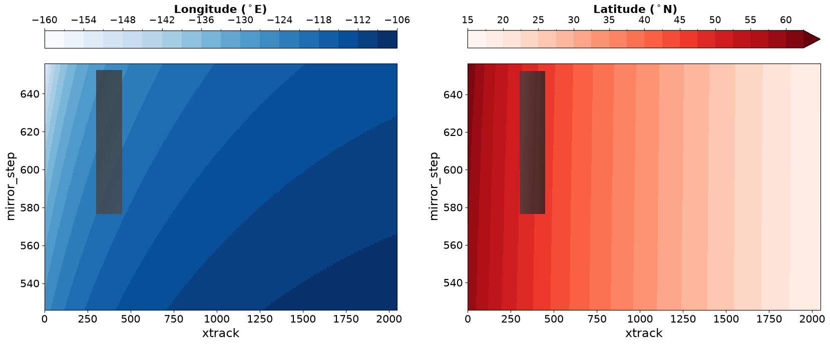
Visualize Coordinates#
Will need to mask arrays for visualizing,
Plot only the last granule
Lon = ds['longitude'].isel(mirror_step=slice(y0, y1), xtrack=slice(x0, x1))

Lon_masked = xr.full_like(ds['longitude'], np.nan)
Lon_masked.loc[dict(
    mirror_step=Lon['mirror_step'],
    xtrack=Lon['xtrack']
)] = Lon


Lat = ds['latitude'].isel(mirror_step=slice(y0, y1), xtrack=slice(x0, x1))
Lat_masked = xr.full_like(ds['latitude'], np.nan)
Lat_masked.loc[dict(
    mirror_step=Lat['mirror_step'],
    xtrack=Lat['xtrack']
)] = Lat
fig, axes = plt.subplots(figsize=(20,8), ncols=2)
pbar_lon = ds['longitude'].plot(ax=axes[0], cmap="Blues", vmin=-160, vmax=-105, levels=np.arange(-160,-105,3), cbar_kwargs={"location": "top"})
pbar_lon.colorbar.ax.tick_params(labelsize=14)
pbar_lon.colorbar.set_label(r'Longitude ($^\circ$E)', fontsize=16, weight='bold')
Lon_masked.plot(ax=axes[0], cmap="Greys_r",vmin=-160,vmax=20, add_colorbar=False, alpha=0.8)

# Optional: Set limits if not automatically handling it
axes[0].set_xlim([ds['xtrack'].min(),ds['xtrack'].max()])
axes[0].set_ylim([ds['mirror_step'].min(),ds['mirror_step'].max()])

pbar_lat = ds['latitude'].plot(ax=axes[1], vmin=15, vmax=62.5, levels=20, cmap='Reds',cbar_kwargs={"location": "top"})
pbar_lat.colorbar.ax.tick_params(labelsize=14)
pbar_lat.colorbar.set_label(r'Latitude ($^\circ$N)', fontsize=16, weight='bold')
Lat_masked.plot(ax=axes[1], cmap="Greys_r",vmin=40,vmax=90, add_colorbar=False, alpha=0.8)


plt.setp(axes[0].get_xticklabels(), fontsize=15)
plt.setp(axes[0].get_yticklabels(), fontsize=15)
axes[0].set_xlabel('xtrack', fontsize=17.5)
axes[0].set_ylabel('mirror_step', fontsize=17.5)

plt.setp(axes[1].get_xticklabels(), fontsize=15)
plt.setp(axes[1].get_yticklabels(), fontsize=15);
axes[1].set_xlabel('xtrack', fontsize=17.5)
axes[1].set_ylabel('mirror_step', fontsize=17.5)
plt.show()
Now define all variables to download#
Vars = dims + [
    "/product/main_data_quality_flag",
    "/product/vertical_column_troposphere",
    "/product/vertical_column_stratosphere",
    "/geolocation/time",
    "/geolocation/longitude",
    "/geolocation/latitude",
    "/support_data/wind_speed",
    "/support_data/terrain_height",
    "/support_data/gas_profile",
    "/support_data/pbl_height",
    "/support_data/temperature_profile",
]
Download data#
At this moment, need to erase any previously downloaded TEMPO_NO2_L2_* data
to avoid filename collision
import os
import glob

fnames = [output_path+f"{fname.split('/')[-1][:-3]}.nc4" for fname in cmr_urls]

for filename in fnames:
    try:
        os.remove(filename)
    except FileNotFoundError:
        print(f"The file '{filename}' is not in there anymore")
%%time
dap_to_netcdf(cmr_urls, session=my_session,
              keep_variables = Vars,
              dim_slices= slices,
              output_path=output_path)
CPU times: user 90.8 ms, sys: 312 ms, total: 402 ms
Wall time: 11.4 s
local_file = output_path+cmr_urls[0].split("/")[-1][:-3]+".nc4"
dst = xr.open_datatree(local_file)
dst
<xarray.DataTree>
Group: /
│   Dimensions:      (xtrack: 150, mirror_step: 76)
│   Coordinates:
│     * xtrack       (xtrack) int32 600B 299 300 301 302 303 ... 444 445 446 447 448
│     * mirror_step  (mirror_step) int32 304B 970 971 972 973 ... 1043 1044 1045
│   Attributes: (12/38)
│       tio_commit:                       482bb1eedf3be832ea377a03017f20b435365760
│       product_type:                     NO2
│       processing_level:                 2
│       processing_version:               4
│       sdpc_version:                     TEMPO_SDPC_v4.7.0
│       scan_num:                         4
│       ...                               ...
│       collection_shortname:             TEMPO_NO2_L2
│       collection_version:               1
│       keywords:                         EARTH SCIENCE>ATMOSPHERE>AIR QUALITY>NI...
│       summary:                          Nitrogen dioxide Level 2 files provide ...
│       coremetadata:                     \nGROUP                  = INVENTORYMET...
│       history:                          2025-10-01T16:37:46Z:/tempo/nas0/sdpc_s...
├── Group: /support_data
│       Dimensions:              (mirror_step: 76, xtrack: 150, swt_level: 72)
│       Dimensions without coordinates: swt_level
│       Data variables:
│           wind_speed           (mirror_step, xtrack) float32 46kB ...
│           terrain_height       (mirror_step, xtrack) float32 46kB ...
│           gas_profile          (mirror_step, xtrack, swt_level) float32 3MB ...
│           pbl_height           (mirror_step, xtrack) float32 46kB ...
│           temperature_profile  (mirror_step, xtrack, swt_level) float32 3MB ...
├── Group: /product
│       Dimensions:                       (mirror_step: 76, xtrack: 150)
│       Data variables:
│           main_data_quality_flag        (mirror_step, xtrack) float32 46kB ...
│           vertical_column_troposphere   (mirror_step, xtrack) float64 91kB ...
│           vertical_column_stratosphere  (mirror_step, xtrack) float64 91kB ...
└── Group: /geolocation
        Dimensions:      (mirror_step: 76, xtrack: 150)
        Data variables:
            time         (mirror_step) datetime64[ns] 608B ...
            longitude    (mirror_step, xtrack) float32 46kB ...
            latitude     (mirror_step, xtrack) float32 46kB ...